Resource consents: are they as scary as they sound?

The short answer is no. Resource Consents aren’t scary IF you have the right people involved. Each one is unique – essentially you are asking Council to let you do something outside a District Plan ‘rule’ or subdivide land. The purpose of the Resource Consent application, is to persuade Council that they should let you do it.
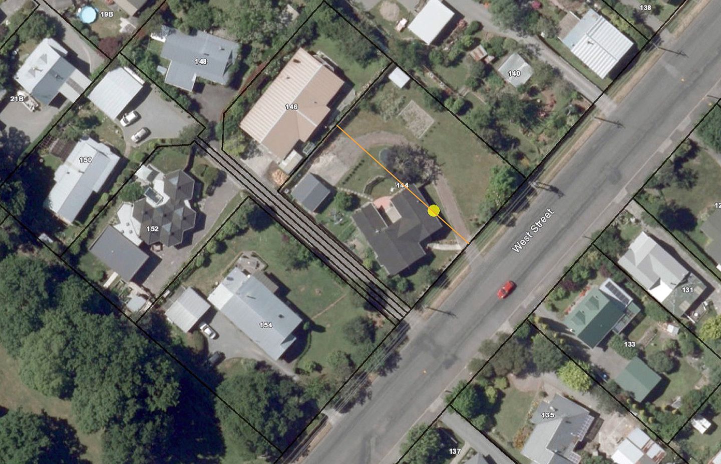
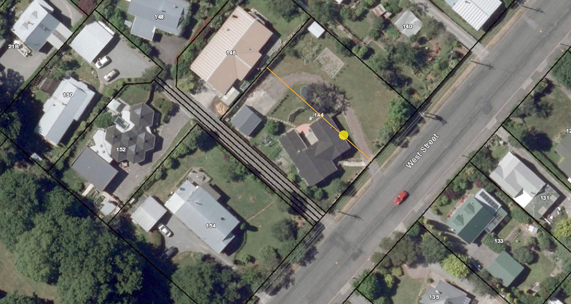
As explained in our last post, we had an issue where an existing boundary between the two lots ran through a corner of the existing house - the orange line in the above image indicates the approximate location of the existing boundary. We would need to alter its position approximately 2.5m to the north, requiring a boundary adjustment, which is essentially starting a subdivision application from scratch.
It is always wise when purchasing a property, or looking to renovate or build, to investigate whether any previous consents had been applied for or issued. As part of our pre-purchase due diligence, we had discovered that a similar application had been made and approved some years ago by previous owners. However Resource Consents only last for five years, so it was no longer valid.
A Resource Consent can be applied for by an owner, or by an agent acting on behalf. You can try and do it yourself but unless you have experience, or a LOT of time (and patience) on your hands, we wouldn’t recommend it. Engaging a professional firm is the best course of action - we regularly prepare them as part of our bespoke design process.
The main guts of a Resource Consent is an Assessment of Environmental Effects (AEE). This is a written document (ours was 5 pages of text) outlining:
- A detailed description of the proposed work and why it needs to happen. Any non-compliance or requests are mentioned here.
- A persuasive explanation, where we pull out all the relevant objectives from the District Plan and state how we are complying with them. For example, one of the Council objectives is to enhance the residential amenity values and local character. One of our points, in response to this was that “the boundary adjustment allows for the residential density of West Street to increase, as it adds to the nucleus of the town, rather than being developed on the outskirts. This adds to convenience of travel for the future residents by promoting walking and cycling over the use of the car”. We are telling Council, that by developing this bare land in the centre of town (as opposed to sections on the outskirts), we are adding value to the centre of town.
As well as the AEE, you will need a set of plans produced for the proposal - ideally professionally produced. This is usually subsequent to the land being surveyed to ensure accuracy in all calculations and dimensions of the proposal. You also need to include the existing certificate(s) of title, to prove ownership, which must be less than 3 months old. All this needs to be submitted to Council with a completed application form for Resource Consent, and a fee paid. Fees vary between different councils and depend on the scope of work - ours was $850. We also had the additional Council infrastructure contribution, as the Habitat lot has no existing infrastructure (sewer, water) – in this case it was close to $16,000, which is a significant amount. Fortunately, we had done our project viability research, so we had foreseen this and factored it in.
However, that’s not the end of it. Even though permission was granted for the new Certificate of Titles to be issued (to reflect the changed sizes of the two sections), we hadn’t got complete approval. We needed to complete the proposed infrastructure work, in order for the Resource Consent to be fully approved. We needed to get a new access-way for each lot established, as well as power, phone, water and sewer connected to the Habitat lot.
We found the best solution was to give the existing house access via the shared driveway to the south (as they already had legal rights). This enabled Habitat to be accessed directly from West St. The Habitat lot also had legal rights to convey services over the shared driveway, so part of the application was to extend this sewer and water right over the rear of the adjacent Lot. It was helpful these rights over the driveway were in place, otherwise larger road works would have been required to bring sewer and water from the other side of West St to the front of the Habitat lot. Power and telecommunications were easiest to draw directly onto the front of the Habitat lot with the services being on the correct side of West St.
With the appropriate permits for the work on the side of West Street approved and then some demolition, a digger, concrete and hard graft later, we were nearly there. Our builder Bryce put up a fence between the two properties, and we also marked out and poured concrete for the start of the driveway for Habitat. Working on the roadside raises another need for compliance, and requires a Traffic Management Permit. We had to have the correct cone layout, compliant cones and road signage (we were told to replace a few cones that had too much wear and tear) and safety procedures in place. Contractors can organise this for you, but bear in mind, all this rigmarole takes time and money.
Only once the new infrastructure was in place, could the new titles be issued and our Resource Consent fully approved. In the meantime, we were hard at work designing the plans and preparing them for consent – more about that in our next post!
Our tip: Get an expert to help, especially if you’ve just read the above and think it all sounds pretty daunting. You are trying to persuade Council to agree to your request, and provide a sound argument with evidence to support this. People with extensive experience can do this really well. Doing it on your own however, may compromise the result. Having prepared numerous Resource Consents for clients as part of their bespoke designs, all of which have been accepted, we consider ourselves well versed on this.